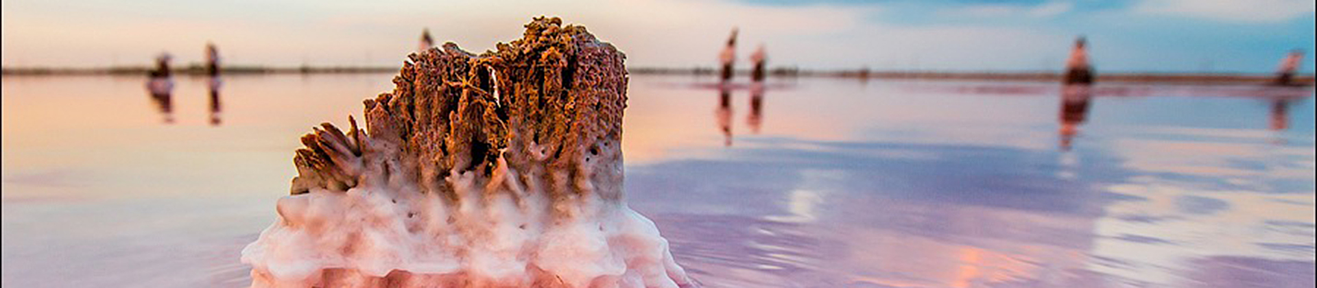
Lake Sasyk-Sivash pink salt lakes.
Perhaps the most beautiful abandoned place in the world
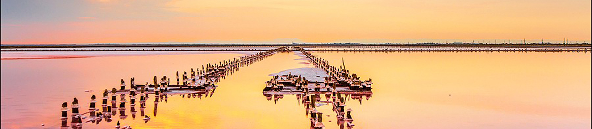
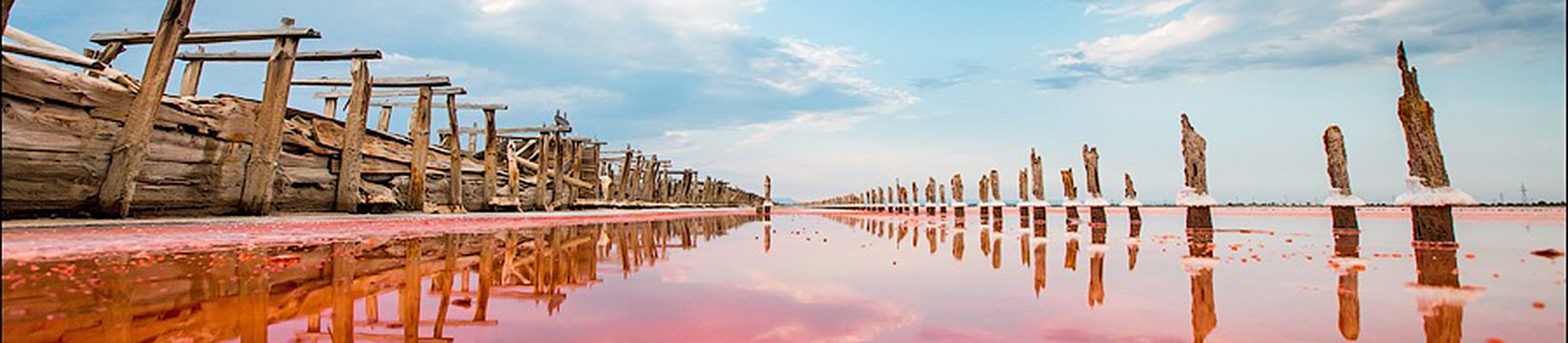
All these incredible water colors, crazy salt columns and cosmic landscapes are abandoned fields for collecting salt located in the Crimea!
Back in Soviet times, these fields were used for mining salt for the needs of the chemical industry. The views here are fantastic – unique combination of bright red water and blue-white-black mud.
Sasyk, Sasyk-Sivash (Ukr. Sasik, Sasik-Sivash, Crimean-tat. Sas─▒q, Sas─▒q S─▒va┼¤, Sasich, Sasyk Sivash of am) is the largest lake and the salt lake on the Crimean Peninsula, located between the cities of Evpatoria and Saki on the territory of the Saksky area and of the city Council Evpatoria (part). Area — 75,3 km2, the catchment area of 1,064 km2. Type total mineralization — salt. The origin of the — estuary. The group of hydrological regime — the drainage.
It is part of a complex landscape reserve of regional importance Sasyk, created on December 21, 2011 with a total area of 5,000 hectares.Sasyk — one of the 6 lakes of the Crimea (others — Achi, Bakal, Small Elkin, Koyash, Chokrak), which is part of the environmental facility.
It is part of the Evpatoria group of lakes. Length — 14 km Width average is 5.5 km; the longest is 9 km, average Depth — 0.5 m; the longest is 1.2 m. the Height above sea level: -0,6 m From the sea, separated by a spit of a width of 0.9 — 1.7 km away. In summer, the area is significantly reduced, the salinity of the water increases.
Sasyk is separated from the Black sea isthmus, through which the highway Evpatoria—Saki and train Yevpatoriya—switch Point. Lake basin reservoir irregular elongated, elongated from West to East. The banks are flat, with the exception of some areas in the East — steep. Rivers don't flow. South shore adjacent to the isthmus is straight and follows the line of the shoreline of the sea; the shore is indented into the land and divided 6 large beams (from West to Vostok Mamakusa, n/a, n/a, Baranovskaya, Nadezhdinskaya, Themes) and suharikami that flow into the lake. The Northern part is separated from the main bulk dam, which stretches across the entire pond from West to East, thus depriving the flow of storm water from the beams to the entire lake. Between the beams Nadezhdinskaya and Temesh coastline deep into the lake-Cape Red, where the quarry.
Okhotnykove at the village at the confluence suhoreche beams Nadezhdinskoye are on the bridge road Saki—Haul and rail freight purpose for quarry Saki—Career. Located on the isthmus checks salt pans. The lake has two channels, which open in the Black sea, located to the West of the railway platform the Sun and North of the Coastal village, the first one has direct access to the sea, the second stretches to the side of Saki lake to the channel of Saki lake with the Black sea. The reset mode of the waters in the sea regulate the water tower and pumping station.
In the West, to the lake Sasyk adjacent Evpatoria on the shore are also located such settlements riona Saks Firth in the West, Ilankai Okhotnykove — northeast, Coastal South-East.
Thickets of water-loving vegetation are common in the North of the lake. The salt marshes located at the isthmus and land at the confluence suhoreche beams Nadezhdinsky (South Okhotnykove). The characteristic color of the lake is linked to the activity of unicellular algae of the species Dunaliella saltwater, generating a significant amount of β-carotene, and microorganisms of the domain archaea. The waters of the lake can acquire a color from pink to intense red.
At the bottom lies the thickness of the bottom sediments: black silt in the upper layer, then gray and steel-gray, sometimes with a bluish tinge. Higher aquatic vegetation develops successfully only in the desalinated upper reaches of lakes and at the outputs of low-mineralized groundwater. The lake is overgrown with aquatic vegetation primarily in the saline areas in the lagoons of the sandbars in the mouths of the tributary beams in the area of the exits of the underground water. There are intensively developing various algae up to the flowering of the water. In some years, algae give the summer lake brine reddish or greenish hue.
Average annual precipitation is about 400 mm. Food: mixed-surface and underground waters of the black sea artesian basin, sea filtration waters.
Due to the storm North-East wind with gusts up to 30 m/s and wave height on lake Sasyk-Sivash up to 1.5 m on April 16, 2013, there was a threat of breaking the dividing dam of lake Sasyk-Sivash by 6, 7 and 8 km.the next day, the wind strength decreased and the situation on the dam stabilized.
Economic value
Mud (silt sulfide coastal type) lakes are classified as therapeutic and this lake is a place of recreation. It is one of 14 mud deposits of the Crimea, having approved by the Council of Ministers of the USSR sanitary protection zone. According to the resolution of the Cabinet of Ministers of Ukraine of 11.12.1996 Ōä¢ 1499 "on approval of the list of water resources belonging to the category of medical", is one of the 13 mud deposits of the Crimea recognized as therapeutic.
At the isthmus with the Black sea there are places of salt industry.
On the isthmus in 2017, two quarries for the extraction of sea sand began to work.
Photos by Sergey Anashkevitch


